
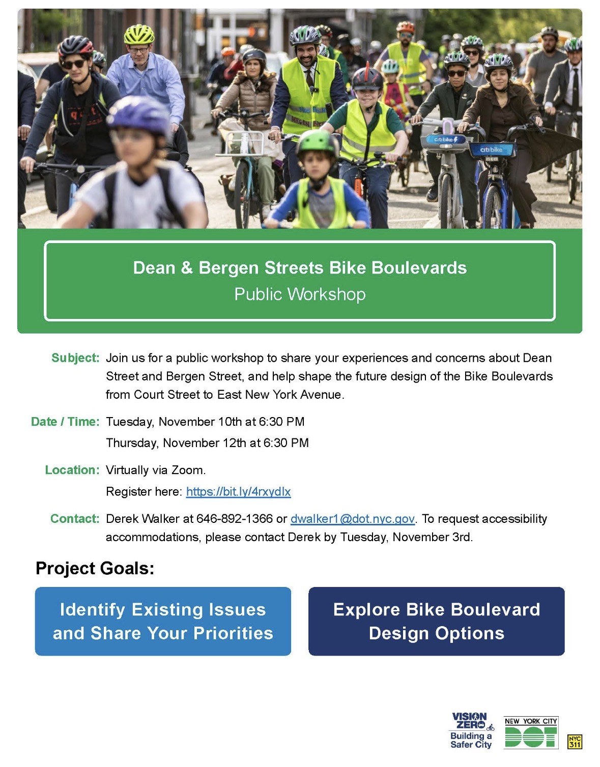
On May 6, 2026, Mayor Zohran Mamdani and NYC DOT Commissioner Mike Flynn announced that Bergen Street and Dean Street, from Court Street to East New York Avenue, will be redesigned as bike boulevards.
Where it stands. Nothing has been designed. DOT's project page has no drawings, project limits or dates, and which stretches get which treatment is not settled. What DOT has opened is a feedback map, where anyone can pin a comment on a spot along the corridor.
This page will be updated as we receive information. Please use the DOT feedback portal, but feel free to email me any comments you send to DOT.
 BKCB2
 BKCB6
 BKCB8
 BKCB16
 Council 33
 Council 35
 Council 36
 Council 37
 Council 39
 Council 41
 Assembly 44
 Assembly 52
 Assembly 55
 Assembly 56
 Assembly 57
 Senate 20
 Senate 25
 Senate 26
 NY-8
 NY-9
 NY-10
 73th Precinct
 77th Precinct
 78th Precinct
 84th Precinct
Bike boulevards on "the Bergen and Dean Street corridors from Court Street to East New York Avenue in Brooklyn," 10 miles of parallel east-west streets, announced May 6, 2026.
DOT runs the project from three places: a project page, a feedback map where anyone can pin a comment, and the Street Design Manual entry that defines a bike boulevard. As of September 27, 2026, none of them holds a design.
nycdotprojects.info/project/dean-bergen-bike-boulevard-project →
nycdotprojects.info/project-feedback-map/dean-bergen-streets-feedback-map
Bergen and Dean cross 4 community boards, 6 City Council districts, 5 State Assembly districts, 3 State Senate districts and 4 police precincts; miles are the length of each street inside each district.
| District | Miles of Bergen St | Miles of Dean St |
|---|---|---|
| BKCB2 | 0.81 | 0.81 |
| BKCB6 | 0.32 | 0.28 |
| BKCB8 | 2.78 | 2.49 |
| BKCB16 | 0.77 | 0.85 |
| District | Miles of Bergen St | Miles of Dean St |
|---|---|---|
| Council 33 | 0.81 | 0.81 |
| Council 35 | 1.21 | 1.26 |
| Council 36 | 1.33 | 1.32 |
| Council 37 | 0.19 | 0.28 |
| Council 39 | 0.26 | 0.20 |
| Council 41 | 0.88 | 0.57 |
| District | Miles of Bergen St | Miles of Dean St |
|---|---|---|
| Assembly 44 | 0.70 | 0.76 |
| Assembly 52 | 1.07 | 1.01 |
| Assembly 55 | 0.77 | 0.85 |
| Assembly 56 | 1.47 | 1.17 |
| Assembly 57 | 0.66 | 0.65 |
| District | Miles of Bergen St | Miles of Dean St |
|---|---|---|
| Senate 20 | 1.78 | 1.47 |
| Senate 25 | 2.09 | 2.16 |
| Senate 26 | 0.81 | 0.81 |
| District | Miles of Bergen St | Miles of Dean St |
|---|---|---|
| NY-8 | 0.92 | 1.53 |
| NY-9 | 2.07 | 1.47 |
| NY-10 | 1.68 | 1.44 |
| District | Miles of Bergen St | Miles of Dean St |
|---|---|---|
| 73th Precinct | 0.77 | 0.85 |
| 77th Precinct | 2.46 | 2.15 |
| 78th Precinct | 0.64 | 0.63 |
| 84th Precinct | 0.81 | 0.81 |
The corridor is 74 blocks: 38 on Bergen Street and 36 on Dean Street, 47,909 feet in all, from the NYC Street Centerline.
Count and share of the 74 blocks, by the district each block's midpoint is in.
| District | Blocks | Share of the 74 blocks | Bergen | Dean | Feet |
|---|---|---|---|---|---|
| BKCB8 | 39 | 52.7% | 21 | 18 | 27,933 |
| BKCB16 | 15 | 20.3% | 7 | 8 | 8,451 |
| BKCB2 | 14 | 18.9% | 7 | 7 | 8,494 |
| BKCB6 | 6 | 8.1% | 3 | 3 | 3,031 |
| District | Blocks | Share of the 74 blocks | Bergen | Dean | Feet |
|---|---|---|---|---|---|
| Council 36 | 21 | 28.4% | 11 | 10 | 13,987 |
| Council 35 | 18 | 24.3% | 9 | 9 | 13,003 |
| Council 33 | 14 | 18.9% | 7 | 7 | 8,494 |
| Council 41 | 10 | 13.5% | 6 | 4 | 7,650 |
| Council 37 | 7 | 9.5% | 3 | 4 | 2,390 |
| Council 39 | 4 | 5.4% | 2 | 2 | 2,385 |
| District | Blocks | Share of the 74 blocks | Bergen | Dean | Feet |
|---|---|---|---|---|---|
| Assembly 56 | 20 | 27.0% | 11 | 9 | 13,911 |
| Assembly 52 | 18 | 24.3% | 9 | 9 | 10,879 |
| Assembly 55 | 15 | 20.3% | 7 | 8 | 8,451 |
| Assembly 44 | 12 | 16.2% | 6 | 6 | 7,705 |
| Assembly 57 | 9 | 12.2% | 5 | 4 | 6,963 |
| District | Blocks | Share of the 74 blocks | Bergen | Dean | Feet |
|---|---|---|---|---|---|
| Senate 25 | 35 | 47.3% | 17 | 18 | 22,268 |
| Senate 20 | 25 | 33.8% | 14 | 11 | 17,147 |
| Senate 26 | 14 | 18.9% | 7 | 7 | 8,494 |
| District | Blocks | Share of the 74 blocks | Bergen | Dean | Feet |
|---|---|---|---|---|---|
| NY-9 | 27 | 36.5% | 16 | 11 | 18,671 |
| NY-10 | 26 | 35.1% | 14 | 12 | 16,378 |
| NY-8 | 21 | 28.4% | 8 | 13 | 12,860 |
| District | Blocks | Share of the 74 blocks | Bergen | Dean | Feet |
|---|---|---|---|---|---|
| 77th Precinct | 35 | 47.3% | 19 | 16 | 24,324 |
| 73th Precinct | 15 | 20.3% | 7 | 8 | 8,451 |
| 84th Precinct | 14 | 18.9% | 7 | 7 | 8,494 |
| 78th Precinct | 10 | 13.5% | 5 | 5 | 6,640 |
Counted from the same files the map draws; a block counts when the feature runs along at least 40% of its length.
| Feature | Blocks | Share of the 74 blocks |
|---|---|---|
| Designated local truck route | 2 | 2.7% |
| Any bike lane in the DOT file | 62 | 83.8% |
| Class II: Conventional | 50 | 67.6% |
| Class II: Conventional Buffered | 9 | 12.2% |
| Class I: Protected | 1 | 1.4% |
| Class II: Curbside Buffered | 1 | 1.4% |
| Class III: Shared | 1 | 1.4% |
| Class II: Curbside | 1 | 1.4% |
| Any bus route on the block | 54 | 73.0% |
| B65 | 50 | 67.6% |
| B15 | 8 | 10.8% |
| B12 | 4 | 5.4% |
| B116 | 3 | 4.1% |
| B63 | 2 | 2.7% |
| B49 | 2 | 2.7% |
| B37 | 1 | 1.4% |
| B65 service the MTA draft would remove | 20 | 27.0% |
| Speed limit | Blocks | Share |
|---|---|---|
| 25 mph | 56 | 75.7% |
| 20 mph | 16 | 21.6% |
| not in the DOT file | 2 | 2.7% |
| Block | Feet | Community board | Council | Assembly | Senate | Congress | Precinct | Truck route | Speed limit | Bike lane | Bus routes | Crashes (window) | 311 (window) |
|---|---|---|---|---|---|---|---|---|---|---|---|---|---|
| Bergen St, Court St to Boerum Pl | 413 | BKCB2 | Council 33 | Assembly 52 | Senate 26 | NY-10 | 84th Precinct | 25 mph | Class II: Conventional Buffered | 17 | 655 | ||
| Bergen St, Boerum Pl to Smith St | 461 | BKCB2 | Council 33 | Assembly 52 | Senate 26 | NY-10 | 84th Precinct | 25 mph | Class II: Conventional Buffered | 2 | 642 | ||
| Bergen St, Smith St to Hoyt St | 682 | BKCB2 | Council 33 | Assembly 52 | Senate 26 | NY-10 | 84th Precinct | 20 mph | Class II: Conventional | B65 | 35 | 1,451 | |
| Bergen St, Hoyt St to Bond St | 674 | BKCB2 | Council 33 | Assembly 52 | Senate 26 | NY-10 | 84th Precinct | 20 mph | Class II: Conventional | B65 | 8 | 917 | |
| Bergen St, Bond St to Nevins St | 675 | BKCB2 | Council 33 | Assembly 52 | Senate 26 | NY-10 | 84th Precinct | 20 mph | Class II: Conventional | B65 | 13 | 968 | |
| Bergen St, Nevins St to 3rd Ave | 611 | BKCB2 | Council 33 | Assembly 52 | Senate 26 | NY-10 | 84th Precinct | 20 mph | Class II: Conventional | B65 | 52 | 809 | |
| Bergen St, 3rd Ave to 4th Ave | 717 | BKCB2 | Council 33 | Assembly 52 | Senate 26 | NY-10 | 84th Precinct | Local | 25 mph | Class II: Conventional | B37, B65 | 13 | 1,594 |
| Bergen St, 4th Ave to 5th Ave | 784 | BKCB6 | Council 39 | Assembly 52 | Senate 25 | NY-10 | 78th Precinct | Local | 25 mph | Class II: Conventional | B116, B63, B65 | 60 | 1,354 |
| Bergen St, 5th Ave to Flatbush Ave | 581 | BKCB6 | Council 39 | Assembly 52 | Senate 25 | NY-10 | 78th Precinct | 25 mph | Class II: Conventional | B116, B65 | 68 | 896 | |
| Bergen St, Flatbush Ave to 6th Ave | 184 | BKCB6 | Council 35 | Assembly 44 | Senate 25 | NY-10 | 78th Precinct | 25 mph | Class I: Protected; Class II: Curbside Buffered | B116, B65 | 55 | 1,119 | |
| Bergen St, 6th Ave to Carlton Ave | 894 | BKCB8 also BKCB6 | Council 35 | Assembly 44 | Senate 25 | NY-10 | 78th Precinct | 20 mph | Class II: Conventional | B65 | 53 | 4,052 | |
| Bergen St, Carlton Ave to Vanderbilt Ave | 911 | BKCB8 | Council 35 | Assembly 44 | Senate 25 | NY-10 | 78th Precinct | 20 mph | Class II: Conventional Buffered | B65 | 11 | 2,553 | |
| Bergen St, Vanderbilt Ave to Underhill Ave | 830 | BKCB8 | Council 35 | Assembly 44 | Senate 25 | NY-10 | 77th Precinct | 20 mph | Class II: Conventional Buffered | B65 | 33 | 1,195 | |
| Bergen St, Underhill Ave to Washington Ave | 414 | BKCB8 | Council 35 | Assembly 44 | Senate 25 | NY-10 | 77th Precinct | 20 mph | Class II: Conventional Buffered | B65 | 4 | 1,284 | |
| Bergen St, Washington Ave to Grand Ave | 481 | BKCB8 | Council 35 | Assembly 44 | Senate 25 | NY-9 | 77th Precinct | 25 mph | Class II: Conventional Buffered | B65 | 28 | 1,181 | |
| Bergen St, Grand Ave to Classon Ave | 893 | BKCB8 | Council 35 | Assembly 57 | Senate 25 | NY-9 | 77th Precinct | 25 mph | Class II: Conventional Buffered | B65 | 24 | 2,850 | |
| Bergen St, Classon Ave to Franklin Ave | 970 | BKCB8 | Council 35 | Assembly 57 | Senate 25 | NY-9 | 77th Precinct | 25 mph | Class II: Conventional | B65 | 23 | 3,701 | |
| Bergen St, Franklin Ave to Bedford Ave | 770 | BKCB8 | Council 35 | Assembly 57 | Senate 20 | NY-9 | 77th Precinct | 25 mph | Class II: Conventional | B65 | 18 | 1,380 | |
| Bergen St, Bedford Ave to Rogers Ave | 106 | BKCB8 | Council 36 also Council 35 | Assembly 57 | Senate 20 | NY-9 | 77th Precinct | 25 mph | Class II: Conventional | B49, B65 | 28 | 131 | |
| Bergen St, Rogers Ave to Nostrand Ave | 771 | BKCB8 | Council 36 | Assembly 57 | Senate 20 | NY-9 | 77th Precinct | 25 mph | Class II: Conventional | B65 | 39 | 3,014 | |
| Bergen St, Nostrand Ave to New York Ave | 770 | BKCB8 | Council 36 | Assembly 56 | Senate 20 | NY-9 | 77th Precinct | 25 mph | Class II: Conventional | B65 | 34 | 2,444 | |
| Bergen St, New York Ave to Brooklyn Ave | 770 | BKCB8 | Council 36 | Assembly 56 | Senate 20 | NY-9 | 77th Precinct | 25 mph | Class II: Conventional | B65 | 26 | 697 | |
| Bergen St, Brooklyn Ave to Kingston Ave | 769 | BKCB8 | Council 36 | Assembly 56 | Senate 20 | NY-9 | 77th Precinct | 25 mph | Class II: Conventional | B65 | 13 | 1,074 | |
| Bergen St, Kingston Ave to Revere Pl | 165 | BKCB8 | Council 36 | Assembly 56 | Senate 20 | NY-9 | 77th Precinct | 25 mph | Class II: Conventional | B65 | 25 | 224 | |
| Bergen St, Revere Pl to Albany Ave | 605 | BKCB8 | Council 36 | Assembly 56 | Senate 20 | NY-9 | 77th Precinct | 25 mph | Class II: Conventional | B65 | 24 | 1,489 | |
| Bergen St, Albany Ave to Troy Ave | 769 | BKCB8 | Council 36 | Assembly 56 | Senate 20 | NY-9 | 77th Precinct | 25 mph | Class II: Conventional Buffered | B65 | 39 | 590 | |
| Bergen St, Troy Ave to Schenectady Ave | 773 | BKCB8 | Council 36 | Assembly 56 | Senate 20 | NY-9 | 77th Precinct | 25 mph | Class II: Conventional | B15, B65 | 36 | 509 | |
| Bergen St, Schenectady Ave to Utica Ave | 770 | BKCB8 | Council 36 | Assembly 56 | Senate 20 | NY-9 | 77th Precinct | 25 mph | Class II: Conventional | B15, B65 | 36 | 769 | |
| Bergen St, Utica Ave to Rochester Ave | 770 | BKCB8 | Council 36 | Assembly 56 | Senate 20 | NY-9 | 77th Precinct | 25 mph | Class II: Conventional | B15, B65 | 46 | 776 | |
| Bergen St, Rochester Ave to Buffalo Ave | 769 | BKCB8 | Council 41 | Assembly 56 | Senate 20 | NY-9 | 77th Precinct | B15, B65 | 26 | 566 | |||
| Bergen St, Buffalo Ave to Ralph Ave | 820 | BKCB8 | Council 41 | Assembly 56 | Senate 20 | NY-8 | 77th Precinct | 25 mph | Class II: Conventional | 26 | 967 | ||
| Bergen St, Ralph Ave to Howard Ave | 721 | BKCB16 | Council 41 | Assembly 55 | Senate 25 | NY-8 | 73th Precinct | 25 mph | 15 | 285 | |||
| Bergen St, Howard Ave to Saratoga Ave | 769 | BKCB16 | Council 41 | Assembly 55 | Senate 25 | NY-8 | 73th Precinct | 25 mph | Class II: Conventional | 22 | 1,699 | ||
| Bergen St, Saratoga Ave to Thomas S Boyland St | 770 | BKCB16 | Council 41 | Assembly 55 | Senate 25 | NY-8 | 73th Precinct | 25 mph | Class II: Conventional | 25 | 2,021 | ||
| Bergen St, Thomas S Boyland St to Rockaway Ave | 770 | BKCB16 | Council 41 | Assembly 55 | Senate 25 | NY-8 | 73th Precinct | 25 mph | Class II: Conventional | 49 | 821 | ||
| Bergen St, Rockaway Ave to Eastern Pkwy | 266 | BKCB16 | Council 37 | Assembly 55 | Senate 25 | NY-8 | 73th Precinct | 25 mph | Class II: Conventional | 46 | 209 | ||
| Bergen St, Eastern Pkwy to Mother Gaston Blvd | 454 | BKCB16 | Council 37 | Assembly 55 | Senate 25 | NY-8 | 73th Precinct | 25 mph | Class II: Conventional | 18 | 146 | ||
| Bergen St, Mother Gaston Blvd to E New York Ave | 254 | BKCB16 | Council 37 | Assembly 55 | Senate 25 | NY-8 | 73th Precinct | 25 mph | Class II: Conventional | 35 | 610 | ||
| Dean St, Court St to Boerum Pl | 444 | BKCB2 | Council 33 | Assembly 52 | Senate 26 | NY-10 | 84th Precinct | 25 mph | 12 | 815 | |||
| Dean St, Boerum Pl to Smith St | 462 | BKCB2 | Council 33 | Assembly 52 | Senate 26 | NY-10 | 84th Precinct | 25 mph | Class III: Shared | 15 | 781 | ||
| Dean St, Smith St to Hoyt St | 680 | BKCB2 | Council 33 | Assembly 52 | Senate 26 | NY-10 | 84th Precinct | 20 mph | Class II: Conventional | 36 | 862 | ||
| Dean St, Hoyt St to Bond St | 675 | BKCB2 | Council 33 | Assembly 52 | Senate 26 | NY-10 | 84th Precinct | 20 mph | Class II: Conventional | 8 | 807 | ||
| Dean St, Bond St to Nevins St | 675 | BKCB2 | Council 33 | Assembly 52 | Senate 26 | NY-10 | 84th Precinct | 20 mph | Class II: Conventional | 13 | 736 | ||
| Dean St, Nevins St to 3rd Ave | 611 | BKCB2 | Council 33 | Assembly 52 | Senate 26 | NY-10 | 84th Precinct | 20 mph | Class II: Conventional | 27 | 645 | ||
| Dean St, 3rd Ave to 4th Ave | 714 | BKCB2 | Council 33 | Assembly 52 | Senate 26 | NY-10 | 84th Precinct | 25 mph | Class II: Conventional | B65 | 30 | 915 | |
| Dean St, 4th Ave to 5th Ave | 785 | BKCB6 | Council 39 | Assembly 52 | Senate 25 | NY-10 | 78th Precinct | 25 mph | Class II: Conventional | B63, B65 | 25 | 1,778 | |
| Dean St, 5th Ave to Flatbush Ave | 235 | BKCB6 | Council 39 also Council 35 | Assembly 52 also Assembly 44 | Senate 25 | NY-10 | 78th Precinct | 25 mph | Class II: Curbside | B65 | 20 | 266 | |
| Dean St, Flatbush Ave to 6th Ave | 462 | BKCB6 | Council 35 | Assembly 44 | Senate 25 | NY-10 | 78th Precinct | 25 mph | Class II: Conventional Buffered | B65 | 82 | 1,990 | |
| Dean St, 6th Ave to Carlton Ave | 894 | BKCB8 | Council 35 | Assembly 44 | Senate 25 | NY-10 | 78th Precinct | 20 mph | Class II: Conventional | B65 | 35 | 4,080 | |
| Dean St, Carlton Ave to Vanderbilt Ave | 910 | BKCB8 | Council 35 | Assembly 44 | Senate 25 | NY-10 | 78th Precinct | 20 mph | Class II: Conventional | B65 | 65 | 4,184 | |
| Dean St, Vanderbilt Ave to Underhill Ave | 830 | BKCB8 | Council 35 | Assembly 44 | Senate 25 | NY-8 | 77th Precinct | 20 mph | Class II: Conventional | B65 | 2 | 1,142 | |
| Dean St, Underhill Ave to Washington Ave | 286 | BKCB8 | Council 35 | Assembly 44 | Senate 25 | NY-8 | 77th Precinct | 20 mph | Class II: Conventional | B65 | 34 | 813 | |
| Dean St, Washington Ave to Grand Ave | 609 | BKCB8 | Council 35 | Assembly 44 | Senate 25 | NY-8 | 77th Precinct | 25 mph | Class II: Conventional | B65 | 26 | 1,072 | |
| Dean St, Grand Ave to Classon Ave | 895 | BKCB8 | Council 35 | Assembly 57 | Senate 25 | NY-8 | 77th Precinct | 25 mph | Class II: Conventional | B65 | 29 | 1,101 | |
| Dean St, Classon Ave to Franklin Ave | 969 | BKCB8 | Council 35 | Assembly 57 | Senate 25 | NY-8 | 77th Precinct | 25 mph | Class II: Conventional | B65 | 36 | 1,741 | |
| Dean St, Franklin Ave to Bedford Ave / Rogers Ave | 801 | BKCB8 | Council 35 | Assembly 57 | Senate 20 | NY-9 | 77th Precinct | 25 mph | Class II: Conventional | B49, B65 | 7 | 1,430 | |
| Dean St, Bedford Ave / Rogers Ave to Nostrand Ave | 788 | BKCB8 | Council 36 | Assembly 57 | Senate 20 | NY-9 | 77th Precinct | 25 mph | Class II: Conventional | B65 | 83 | 1,216 | |
| Dean St, Nostrand Ave to New York Ave | 771 | BKCB8 | Council 36 | Assembly 56 | Senate 20 | NY-9 | 77th Precinct | 25 mph | Class II: Conventional | B65 | 29 | 1,489 | |
| Dean St, New York Ave to Brooklyn Ave | 770 | BKCB8 | Council 36 | Assembly 56 | Senate 20 | NY-9 | 77th Precinct | 25 mph | Class II: Conventional | B65 | 19 | 1,276 | |
| Dean St, Brooklyn Ave to Kingston Ave | 770 | BKCB8 | Council 36 | Assembly 56 | Senate 20 | NY-9 | 77th Precinct | 25 mph | Class II: Conventional | B65 | 30 | 1,450 | |
| Dean St, Kingston Ave to Revere Pl | 164 | BKCB8 | Council 36 | Assembly 56 | Senate 20 | NY-9 | 77th Precinct | 25 mph | Class II: Conventional | B65 | 6 | 381 | |
| Dean St, Revere Pl to Albany Ave | 605 | BKCB8 | Council 36 | Assembly 56 | Senate 20 | NY-9 | 77th Precinct | 25 mph | Class II: Conventional | B65 | 24 | 366 | |
| Dean St, Albany Ave to Troy Ave | 771 | BKCB8 | Council 36 | Assembly 56 | Senate 20 | NY-9 | 77th Precinct | 25 mph | Class II: Conventional | B15, B65 | 25 | 956 | |
| Dean St, Troy Ave to Schenectady Ave | 770 | BKCB8 | Council 36 | Assembly 56 | Senate 20 | NY-9 | 77th Precinct | B15, B65 | 31 | 563 | |||
| Dean St, Schenectady Ave to Utica Ave | 770 | BKCB8 | Council 36 | Assembly 56 | Senate 20 | NY-9 | 77th Precinct | 25 mph | Class II: Conventional | B15, B65 | 32 | 781 | |
| Dean St, Utica Ave to Rochester Ave | 770 | BKCB8 | Council 36 | Assembly 56 | Senate 20 | NY-9 | 77th Precinct | 25 mph | Class II: Conventional | B15, B65 | 27 | 1,129 | |
| Dean St, Ralph Ave to Howard Ave | 720 | BKCB16 | Council 41 | Assembly 55 | Senate 25 | NY-8 | 73th Precinct | 25 mph | 30 | 338 | |||
| Dean St, Howard Ave to Saratoga Ave | 770 | BKCB16 | Council 41 | Assembly 55 | Senate 25 | NY-8 | 73th Precinct | 25 mph | 30 | 1,134 | |||
| Dean St, Saratoga Ave to Thomas S Boyland St | 769 | BKCB16 | Council 41 | Assembly 55 | Senate 25 | NY-8 | 73th Precinct | 25 mph | 29 | 715 | |||
| Dean St, Thomas S Boyland St to Rockaway Ave | 772 | BKCB16 | Council 41 | Assembly 55 | Senate 25 | NY-8 | 73th Precinct | 25 mph | 29 | 210 | |||
| Dean St, Rockaway Ave to Eastern Pkwy | 511 | BKCB16 | Council 37 | Assembly 55 | Senate 25 | NY-8 | 73th Precinct | 25 mph | B12 | 29 | 530 | ||
| Dean St, Eastern Pkwy to Mother Gaston Blvd | 214 | BKCB16 | Council 37 | Assembly 55 | Senate 25 | NY-8 | 73th Precinct | 25 mph | B12 | 14 | 572 | ||
| Dean St, Mother Gaston Blvd to Sackman St | 565 | BKCB16 | Council 37 | Assembly 55 | Senate 25 | NY-8 | 73th Precinct | 25 mph | B12 | 16 | 788 | ||
| Dean St, Sackman St to E New York Ave | 126 | BKCB16 | Council 37 | Assembly 55 | Senate 25 | NY-8 | 73th Precinct | 25 mph | B12 | 13 | 144 |
Today the B65 "runs between Downtown Brooklyn and Crown Heights" over 4.4 miles; the draft plan shortens it to 4.1 miles and would reroute it "to travel on Atlantic Av in both directions between Downtown Brooklyn and Washington Av," discontinuing service on "Dean St and Bergen St west of Washington Av".
Route-wide average speed for the B65 and the B63, which runs along 5th Avenue across Bergen and Dean (its timepoints in the same data are mostly on 5 Av), calculated as total distance over total travel time from the MTA's segment speed data: B65 2023 to 2024, B65 2025 on, B63 2023 to 2024, B63 2025 on.
Bergen Street is a designated local truck route from 3rd Avenue to 5th Avenue, in BKCB2 and BKCB6, 4 segments on the truck routes map. Dean Street has no truck route segments.
NYPD crash reports with a mapped point within 100 feet of each street, . The time window reaches back to January 2013, the first full year in the NYPD file.
Each month's crashes divided by miles of streets: Bergen 4.67 and Dean 4.44 miles, Brooklyn 1,515 miles of streets, counting records labeled Brooklyn, a floor.
Calendar years inside the window; a year the window only partly covers is marked *.
From each crash's date.
From the NYPD crash_time field.
Shown for windows of two years or less.
The corridor's own blocks inside each of the four districts it crosses, against that whole district's streets, per mile per year in this window. Whole-district counts are every crash inside the district boundary; street miles from the NYC Street Centerline, streets only.
311 service requests with a mapped point within 100 feet of each street, ; months before 2020 come from the 2010 to 2019 file. A request is one call or app report, not one problem: the same parked car or the same cold building can produce many, and a request is not a confirmed condition. The 100-foot band takes in the buildings on both sides of the street, so building complaints (heat and hot water, noise from a residence) count alongside street complaints.
The most common request types on each street in this window (the 14 most common types over the full record are listed; the rest are "Other types").
By the month the request was made: Bergen and Dean from 2020 on, Bergen and Dean before 2020.
Requests are mapped to an address, so a street's band picks up the buildings along it, while a borough-wide rate spreads every request over every street, including streets with few buildings; denser blocks with more apartments produce more requests of every kind.
From the time the request was made.
Shown for windows of two years or less.
NYC DOT has built four bike boulevards: Berry Street in Williamsburg, 39th Avenue in Sunnyside, Underhill Avenue in Prospect Heights and 31st Avenue in Astoria. Each is mapped with the bike facilities DOT's file shows on it today, and the table puts them next to Bergen and Dean on the same measures for the chosen time window, with crashes and 311 requests counted within 100 feet of each street's centerline.
Questions the public record does not yet answer, with where each comes from.
Every count links to the public data or document it comes from. None is a projection of the final design, which the city has not released.
Open data queried September 26, 2026; DOT feedback map read September 27, 2026.